

We can design streets that are safe for everyone, here's how:
We can design streets that are safe for everyone, here's how:
The City of Gainesville is committed to eliminating traffic deaths on our roads. We know how to get there, now we just need to get the plans, projects, and staffing to do it.

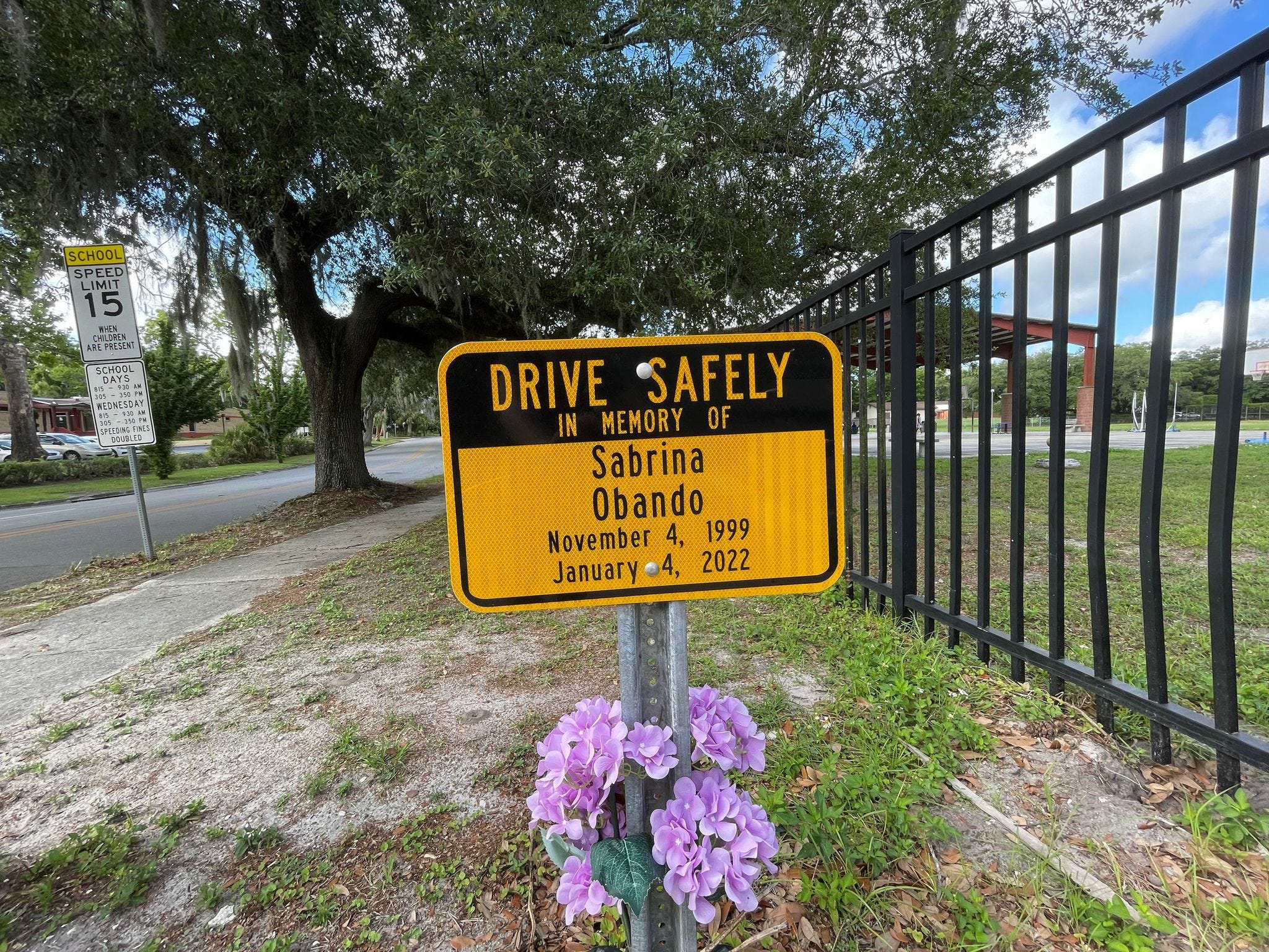
On January 4th, 2022 at 12:30 pm Sabrina Obando was walking home from her job as a hostess at at Crane Ramen. Sabrina was 22, just graduated from the University of Florida, and was in that transition period between graduating college and starting her career. As she was crossing 8th Avenue on 10th Street going north a Ford F-150 just so happened to be turning left at the same time. Sabrina was hit and killed instantly.
Her friends and family were devastated, as beautifully written in an article in the Independent Alligator one week later.
To be Sabrina Marie Obando’s friend was to be showered in love, laughter and light.
Madison Bushloper, her close friend, recounted their relationship as stronger than a family member.
“She never failed to bring out the best in everyone,” Bushloper wrote in a text message. “I always felt my most vibrant and joyous when in her presence.”
I think about Sabrina a lot, though we never met. The road she was hit on is in our neighborhood. My wife used to cross it daily at the time, taking our newborn in her stroller to explore Fifth Avenue1. There was no reason it had to be Sabrina, it could have been my wife, my daughter, anyone really. No one was at fault, everyone followed traffic rules, but now Sabrina is gone. A memorial to her life sits permanently on that intersection and serves as a constant reminder to me every time I cross it on my bike going south.
Sabrina is one of 165 people killed in the last 10 years on streets in the City of Gainesville. Those who lost their lives were diverse: young and old; black and white; walkers, bikers, and drivers. They include Maggie Paxton, Sophia Lambert, Jarret Young, Prateek Sharma, DJ Washington, and Denise Griffiths, all killed before they turned 30.
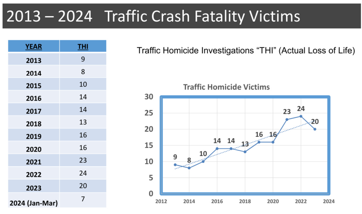
Gainesville, like everywhere else in the country, has seen a heartbreaking and startling rise in deaths on our roads. The number of deaths has more than doubled in the past decade, with 7 so far this year, putting us on track for the deadliest year on record.
It’s easy to write these deaths off as “traffic accidents”. We have become so numb to traffic-related deaths that they fall into the background. But it’s a numbness we don’t feel for any other tragic death. When a condominium falls in Surfside we try to understand why and change policies to make sure it never happens again. If a child is hurt on a city playground we redesign and work to fix it. When shootings began ticking up during the pandemic there was mass public outcry, even as traffic fatalities outpaced murders as a cause of death.
I get it, it can feel hopeless, but traffic deaths aren’t something we have to live with. In Europe, traffic deaths per capita are half of what they are in the United States, and ours are skyrocketing as theirs are falling. In many cities an aggressive focus on reducing traffic deaths has shown results. A recent study of New York City found that Vision Zero policies have resulted in a 30% reduction in traffic injuries. Hoboken, New Jersey has not had a death on their roads in seven years.
Roads are public spaces, owned by us, and maintained by our tax dollars. If people are dying on our shared public land we need to know why it’s happening and find solutions to solving it.
Who is being killed on our roads and why
In 2020, as the traffic death rate was rapidly rising, the City Commission passed a resolution to eliminate serious injuries and deaths on our roads by 2040, to become a “Vision Zero City”. It was a bold goal, but one adopted by many cities across the Country.
In response, the city came out with a Vision Zero Action Plan and began working towards altering our roads to emphasize safety instead of just car speed. You can see a great map of all the planned projects here.
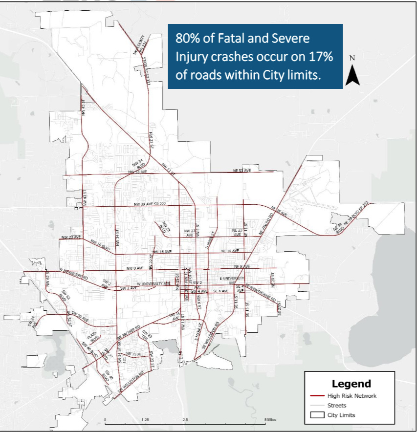
There’s a lot of good data in the report, and more has come out since. The vast majority of injuries occur on high-speed roads that run directly adjacent to our main pedestrian areas. These are roads with speeds as high as 45 mph, running directly by the University of Florida, elementary schools, and public parks.
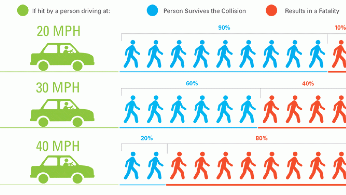
As this great chart below by the City of Raleigh, North Carola makes clear, small changes in car speed make a huge impact on how likely you are to survive a hit. Being hit by a car going 20 mph results in fatality 10% of the time, while going just 10 mph faster, 30 mph, quadruples that to 40%. By the time car speeds hit 40 mph you are very unlikely to survive as a pedestrian.
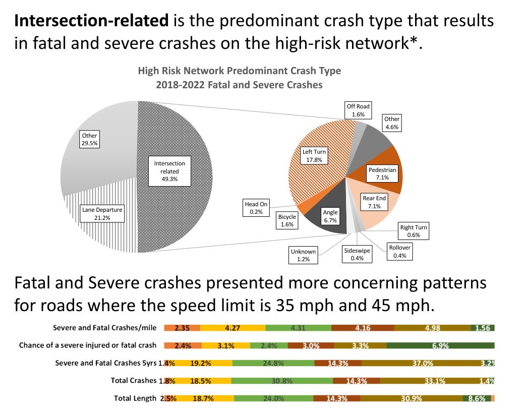
This shows up in Gainesville-specific data as well. According to the Gainesville Department of Transportation the severe crashes per mile of road for roads at 45 mph is double that of roads at 25 mph.
Arterial2 roads of 35-45 mph are the norm throughout the City. Next time you drive on 34th and 8th look around you. In this little area, you are surrounded by an elementary school (Littlewood Elementary), a middle school (Westwood Middle School), an active park (Westside Park), hiking trails (Loblolly Woods), and arguably Gainesville’s best pool (H. Spurgeon Cherry at Westside Park).
The speed limit on 34th and 8th is 35 mph, but people rarely drive that speed. At 40 mph anyone who steps into traffic in that area has only a 20% chance of survival. This is an area that is filled with kids throughout the day going to school, the pool, and the park.
So what happened here? Why are these roads where they are?
The rise of the stroad
Here are three photos of University Avenue looking east, taken in the 1940’s (top left), 1960’s (bottom left), and 1970’s (right). The Segal building helps to give context.


Just eyeballing the photos, the impact is obvious. In the 1940’s-1960’s University Avenue was our main shopping street. It connected the University to downtown with on-street parking on each of side the street and ample street trees to create a walkable experience. But by the 1970’s the road became a state highway, transformed into a five-lane thoroughfare with no street trees and high speeds. What happened during this time?
Well, traffic engineering happened.
In the 1950’s and 60’s the field of transportation engineering blossomed out of the engineering marvel that is the federal highway system. Engineers learned and distributed an amazing amount of information about how to keep cars moving quickly on high-speed roads safely.
Long offramps were designed to exact specifications to move cars quickly off the highways. “Clear zones” were created, large empty spaces on each side of the highways that gave room for veering without hitting anything at high speeds. The amount of detail and thought that had gone into our highways is amazing, and it is possibly the most impactful investment America has ever made, both for good and bad.
But those same design best practices for highways are completely antithetical to the needs of a living city. “Clear zones” mean no street trees or streetlights, which are needed for comfort and safety. Wide roads with fast cars are hard to cross and uncomfortable. These fast cars are four times as likely to kill a pedestrian.
In the 1970s 13th Street and University Avenue were transferred from the City to the State of Florida and became “state-owned highways”. What was once a slow storefront street became empty shops and gas stations. No one wants to relax and shop next to a highway.
University Avenue became a “stroad” a mix of a high-speed road and storefront street. Here is how former traffic engineer and founder of Strongtowns Chuck Marohn describes a “Stroad:
Streets: The function of a street is to serve as a platform for building wealth. On a street, we're attempting to grow the complex ecosystem that produces community wealth. In these environments, people (outside of their automobiles) are the indicator species of success. Successful streets are environments where humans, and human interaction, flourish.
Roads: In contrast, the function of a road is to connect productive places. You can think of a road as a refinement of the railroad — a road on rails — where people board in one place, depart in another and there is a high speed connection between the two.
Stroads: Stroads are a mash-up of these two types of paths. We like to call them "the futon of transportation" because, just as a futon is neither a particularly good bed nor a particularly good couch, a stroad is neither a particularly good road or a particularly good street.
University Avenue is the dictionary definition of a “stroad”. It is a high-speed, five-lane road directly across from the University of Florida, a primarily pedestrian campus, and separates the main campus from the shops, apartments, and bars that these same students use every day. It is both miserable to walk on and miserable to drive on, failing as both a storefront street and a thoroughfare.
It’s not only frustrating but downright deadly. Between 2015-2022 16 people lost their lives along University Avenue.
How to do better
The solutions can be big and small, from simply connecting sidewalks where there aren’t any, to planting street trees, to full road redesigns.
Aesthetic design changes
One of the main concepts traffic engineers missed in the 1960’s, but we understand much better today, is that driving is as much psychology as geometry. When you’re driving down a road that feels like a highway, you’re going to drive like it’s a highway. Wide lanes, empty “clear zones”, and long and straight stretches result in fast cars, no matter what the “speed limit” signs say.
Studies have shown that simple aesthetic changes like planting street trees, reducing lane widths, or putting in public art reduces dangerous driving and improves safety. Most drivers don’t want to speed through urban areas and risk lives, and small design choices help to subconsciously differentiate between these street types.
The best Youtube Channel, and probably the best writer on multimodal transportation period, is “Not Just Bikes” by Jason Slaughter. Not Just Bikes makes videos about transportation planning in his home country of the Netherlands and compares it to North America, and it’s fantastic. Here’s a good video about the psychology of driving, and why speed limits don’t work to slow traffic:
Protected Bike Lanes
In 1974 the first bike lane in the city was installed, on NW 34th St north of 16th, in response to the death of a 13-year-old on his bike.
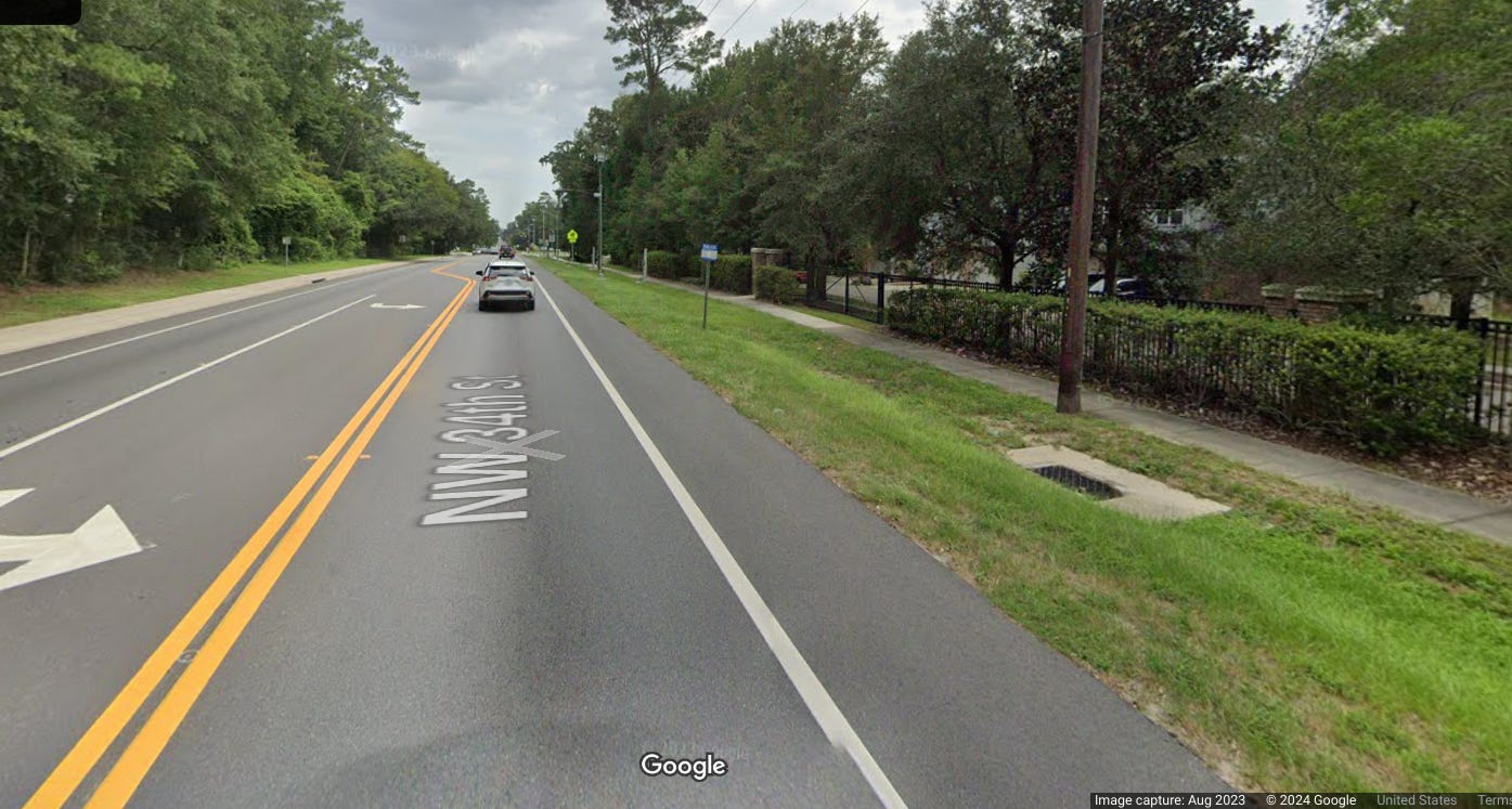
Almost immediately cyclists came out and said this wasn’t adequate, but it was better than nothing. They’re right, I know very few people who feel comfortable riding their bike in a 4-foot painted bike lane like this.
And that’s because it’s unsafe! This section of 34th has 26,000 cars per day traveling a minimum of 35 mph, but generally more like 45 mph. As the chart above shows, if just one of those cars veers into your lane as you’re riding you have a 20% chance of survival. That’s a crazy risk to take to just ride your bike.
The best practice today is to create “protected bike lanes” which put some actual, physical protection between you and a car. Last year the City Commission put NACTO’s bike standards into our engineering guidelines that require all repaved high-speed, busy roads be fitted with protected bike lanes.
At the moment we don’t have much of these around, but one good example of what this can look like is right across from the University of Florida. In 2022 NW 17th and NW 18th near University Avenue were converted from a 2-lane road to two one-way roads with protected bike lanes on each side of them, called “one way pairs”.


These aren’t high-speed roads, but they are heavily trafficked by bikes and pedestrians in front of our most dangerous road, University Avenue. Hopefully, we’ll see more of this in the coming years.
Creating Safer Intersections
49.3% of all severe injuries and deaths on our roads happen at intersections. Intersections are chaotic for cars, bikes, and pedestrians, and with so much going on it’s easy for mistakes to happen.
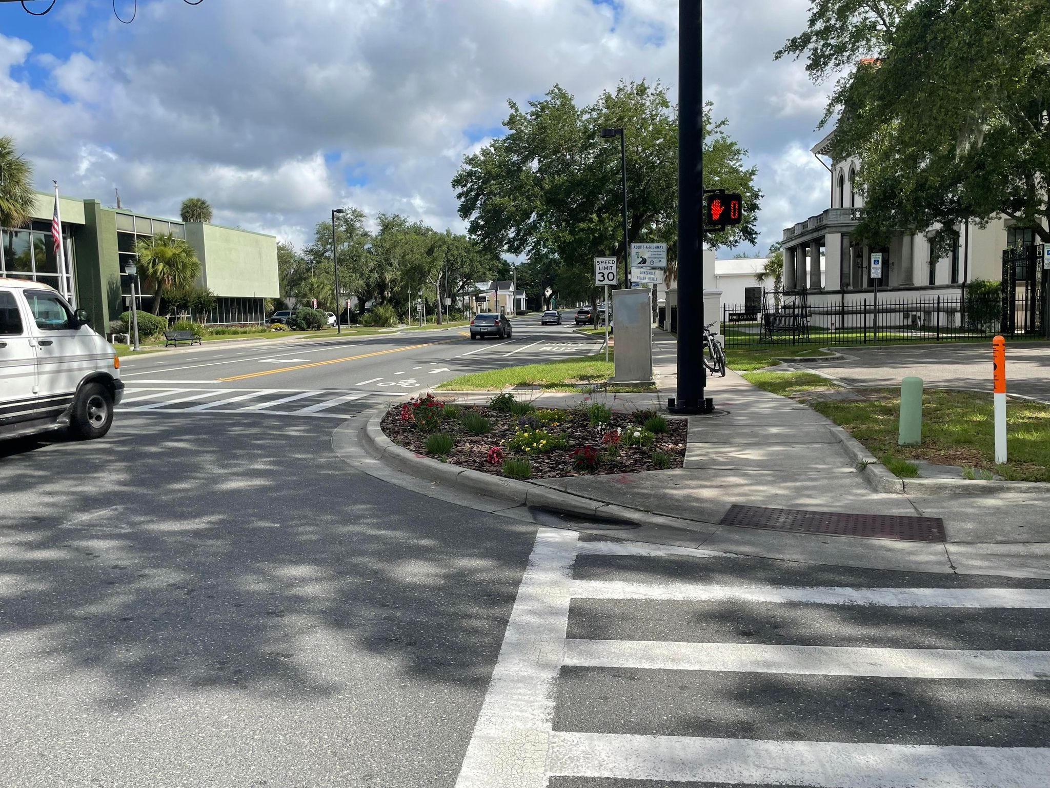
To give more visibility to pedestrians “leading pedestrian intervals” were implemented in our most walkable areas. These are walk signs that go on just a few seconds before the light turns green, to give pedestrians some time to walk before cars go so there aren’t blind collisions with both cars and people crossing at the same time. Here’s a video I took on 2nd Ave and 13th St to illustrate. Watch when the walk sign comes on and the light turns green.
Just giving more visibility at crosswalks can make a big difference as well. You’ll notice in our more walkable areas “curb extensions”. These extend the curb and shorten the distance pedestrians have to walk to cross. Most important, it gives visibility to pedestrians crossing. You can even add in little gardens like this one on NW 2nd Ave and Main St, which are both pretty and help to create permeable surfaces to reduce flooding.
Full Road Redesigns
Most intensive, but also most impactful, is a full road redesign, to reverse the massive overbuilding of roads that took place in the 1970’s. The most successful and high-profile example of this is the Main Street redesign in the early 2010’s.


Main Street transformed from a 4-lane highway to a 3-lane road with on-street parking, bike lanes, and curb extensions. It’s been a huge success, making walking safer and much more pleasant in downtown. It was also incredibly controversial at the time, as road redesigns tend to be.
According to FDOT’s analysis of this change, this reduced average speed on Main St by 2.1 MPH, but more importantly, it reduced crashes on Main Street by 2/3, from 59 to 18.
Structural Changes in Our Transportation Planning
Transportation planning is going through a bit of a revolution at the moment. A field that has been focused solely on car-centric design is just now beginning to consider other forms of transportation.
Organizations like NACTO are studying and creating guidelines that prioritize pedestrians, cyclists, and buses within urban areas. The Florida Department of Transportation, a conservative and car-centric agency if there ever was one, has required much better bicycle standards recently and has been working with the City on creating more safety improvements on state roads in Gainesville. These are little wins, it’s going to take time to change a very entrenched culture within the field.
While small and big projects are the physical way we move this forward, there are a few structural and policy ways we move forward as well:
Create standards and plans for long-term multi-modal transportation
Have transportation staff that prioritize all modes of transportation, and have enough of them to do the work
Fund public works and road rebuilding to update to these new standards
Thankfully we have some long-term solutions for this, creating long-term plans and expanding our transportation planning staff locally, even in the midst of budget cuts.
Master Plans for Transportation
The City and County currently have no long term master plans for multi-modal transportation, which puts us far behind other comparable communities.
Two big plans are coming out soon are being done in coordination with the County: the Countywide “Bicycle Pedestrian Master Plan” and the “Safe Streets for All Action Plan”. The Bicycle Pedestrian Master Plan plan will be planning an “All Ages and Abilities” network across the County, highlighting certain roads and corridors for better designs that bring people north to east to south. The Safe Streets for All Action Plan is a vision zero plan that will dig into where crashes are occurring and what caused them, with specific recommendations for redesigning them for safety.
Plans like these are the meat of getting things done in government, particularly projects as expensive as road designs. If you’re interested in getting more involved with crafting these plans community engagement is starting soon on both.
A Robust, Responsive MTPO
The Gainesville MTPO, the metropolitan transportation planning organization, is the main transportation coordinator of our area. They work with the federal government, State of Florida, Alachua County, and cities in our area to plan a coordinated transportation system. Basically, if you want anything done on a state road in Alachua County it goes through them, but they also work on County and City roads as well. This board is overseen by the entire Gainesville City Commission and the entire County Commission.
For years this organization has been an afterthought, outsourced to the North Central Florida Regional Planning Council, where elected officials outside of Alachua County are their main oversight. It’s an outdated model that needs a refresh.
On June 3rd the MTPO board is discussing changing this arrangement, and I have a proposal to transition our consultant MTPO to an independent MTPO. This will give our community much more control and accountability for our transportation planning, and it’s sorely needed. The vast majority of deaths on our roads happen on state roads. Without an energetic and robust MTPO there’s no way we can seriously reduce injuries and deaths on our roads.
Roads Can be for Everybody
Transportation is all about context. There’s no question, people need to get around quickly in their cars. Every minute in traffic is a minute not spent with family, friends, or doing the things people love. But we need to create options that allow everyone to get around, particularly in our city center. Roads are public spaces, they need to be for everyone in the public.
Gainesville is a pedestrian and cycling town, and has been for decades. We’re a college town, where the best and brightest across Florida and the US come to become professionals. We deserve to give all of our residents the chance to live close to where they work and learn, and the ability to get there safely.
That’s not going to be a fast process, but we know what we have to do to get there.
My wife pretty much quit crossing 8th after Sabrina’s death. Like gun violence, traffic violence impacts more than just the people killed, it creates fear and uncertainty for an entire community and changes the way we interact with our city.
“Arterial road” is transportation planner speak for high-speed roads that are 2nd highest in the “road hierarchy”. The hierarcy goes Freeways > Arterials > Collectors > Local Roads. Archer Road, 34th, and 16th are good examples.
Your blog posts are always so thorough and well written and bring up important issues. Thank you and keep up the great work.
Great column, as always, Bryan. I am so glad to hear this issue getting the proper attention it deserves. A few years ago I and a young person with a bike were about to cross 13th St near University. It was just starting to rain, so everyone was scrambling to get where they needed to be. The light turned, the walk sign came on, and we both started to go. I noticed at the very last second that an oncoming vehicle was about to run that light. I stopped and yelled to the other person, who was a step or two ahead of me, to stop. They turned around to see why I was yelling at them just as the other car whizzed through the intersection. I have no doubt in my mind that the two of us were a heartbeat away from being a statistic referred to in your article. And I'm confident that pretty much everyone who reads your column can name someone close to them who has been personally affected by this epidemic of traffic injuries/fatalities.
My biggest question coming away from this post is what role traffic enforcement plays. I've lived in Gville for 16 years now and it wouldn't be much of an exaggeration to say that I can count on two hands the number of times I've seen GPD pulling people over in this town. Meanwhile, I routinely see people running red lights and doing some serious speeding and very aggressive driving, sometimes right on 6th Street (near where I live and drive the most) within a stone's throw of GPD HQ. This is one of the few areas where I, personally, would really like to see more policing. Thanks!